Da Nang (Đà Nẵng) Beaches: Where to Swim and Where to Go for the Views
My Khe (Mỹ Khê) and the Pham Van Dong (Phạm Văn Đồng) stretch have buoys, lifeguards and freshwater showers, but they are busy and loud from first light. Son Tra (Sơn Trà) and Nam O (Nam Ô) are quieter and prettier, with few patrolled swimming areas, so we suggest going for the scenery rather than planning a swim.
Written by Tụi mình mê biểnPublished Updated
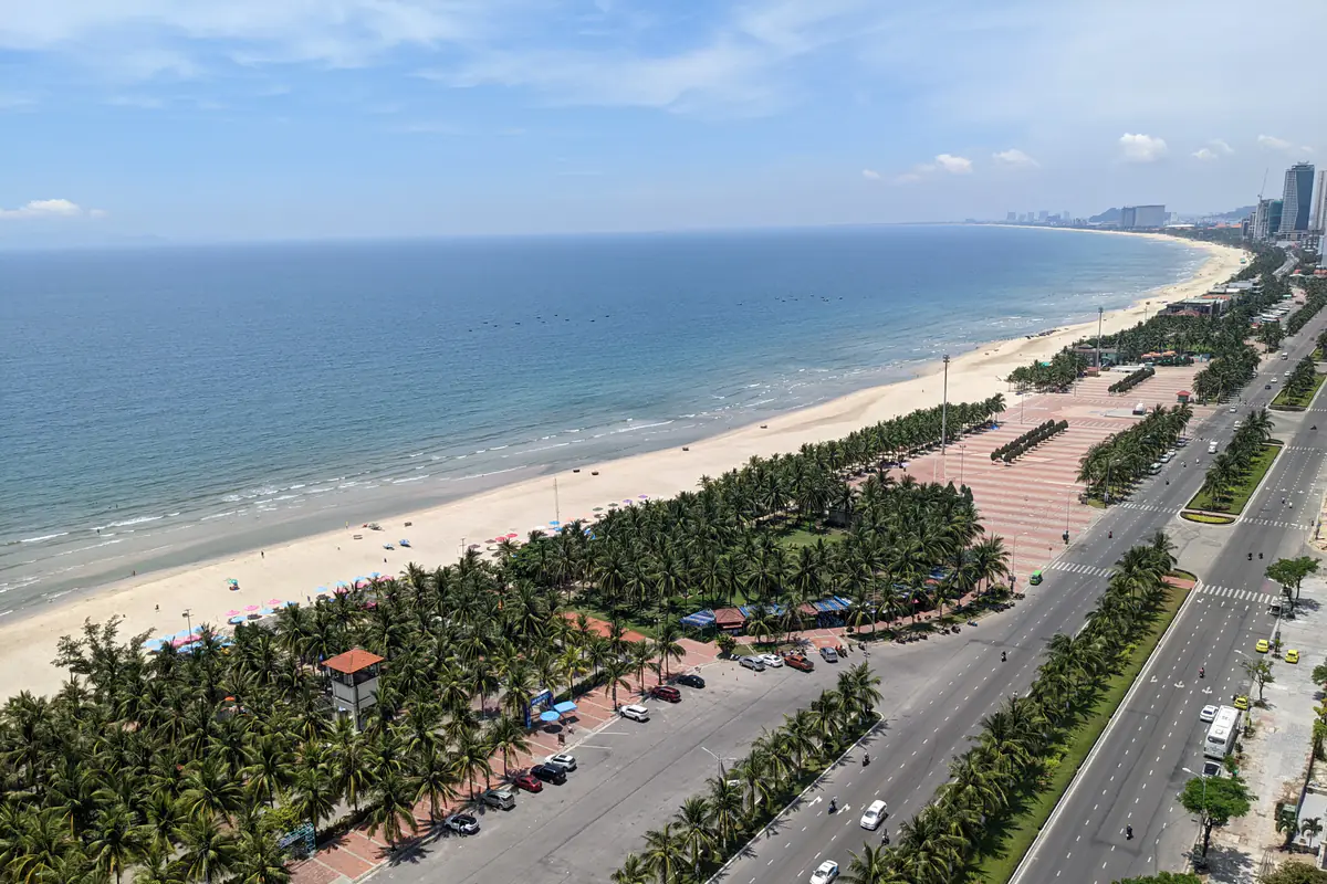
Photo: Jpatokal
A buoy line running parallel to the shore and a flag planted in the sand next to the lifeguard tower: on Da Nang's beaches, those two things decide whether you swim or stay on the sand. Inside the buoys in front of Bien Dong Park (Công viên Biển Đông), older locals swim slow lengths from before first light, watched by a lifeguard in red and yellow.
The eastern beach runs from the foot of Son Tra down to Non Nuoc (Non Nước), with stretches known as Pham Van Dong, My Khe and Non Nuoc. Nam O lies across the bay, below the Hai Van (Hải Vân) Pass.
Which Da Nang beach for what #
| Beach | Good for | Safety note |
|---|---|---|
| Pham Van Dong, the beach by Bien Dong Park, about 4 km | Small children, a freshwater rinse after swimming | Buoyed zone next to the showers, easy for watching kids; go in once the tower is staffed. |
| My Khe, along Vo Nguyen Giap (Võ Nguyên Giáp) street, 4-5 km | Beachfront hotels, an early swim before breakfast | Walk to the nearest buoyed zone; avoid empty stretches and drain outlets after rain. |
| Non Nuoc, along Truong Sa (Trường Sa) street, about 11 km | Resort stays in the south, pairing with the Marble Mountains (Ngũ Hành Sơn) | Buoyed zones are further apart; ask where lifeguards are on duty before going in. |
| Son Tra: Bai But (Bãi Bụt) and Tien Sa (Tiên Sa), 11-14 km | A scenic ride, forest, sea views and photos | No buoys and no lifeguard tower means look, don't swim; stay out of signed no-go areas. |
| Nam O, at the foot of the Hai Van Pass, about 15 km | A fishing village and rock reef; early morning or late afternoon | We would not swim here. |
Driving distances from the Dragon Bridge (cầu Rồng), measured on a map; real routes vary.
Pham Van Dong and My Khe: the swimming beaches
For your first swim in Da Nang, we suggest the beach in front of Bien Dong Park, at the end of Pham Van Dong street. It is a public beach with freshwater rinse tubs, rows of showers and changing rooms. The buoyed zone has lifeguards; go in only inside the buoys, and only once the tower is staffed. For the showers, scooter parking or a lounger, check the posted price or ask first, and keep your parking ticket safe.
South from here along Vo Nguyen Giap is the stretch most visitors simply call My Khe, in front of most of the beachfront hotels. Look up the buoyed zone closest to your hotel and walk to it rather than wading in right outside the lobby.
After rain, even light rain, wastewater sometimes spills onto the beach from storm drains, for example opposite the An Thuong (An Thượng) area. If you see murky, smelly water coming out of a drain, move well away and use another zone.
Non Nuoc: more space, more resorts
Non Nuoc is the nearly 5 km stretch along Truong Sa street, below the Marble Mountains, with resorts along much of the frontage. It is still on the lifeguard route, but buoyed zones are further apart, so ask your hotel or a lifeguard which stretch is patrolled before going in. Staying down here, we would climb Thuy Son (Thủy Sơn) early and swim in the late afternoon once the sun softens.
Son Tra: Bai But and Tien Sa for the views
Bai But lies below Linh Ung (Linh Ứng) Pagoda, reached by Hoang Sa (Hoàng Sa) road along the foot of the mountain. Tien Sa is at the other end of the peninsula, next to Tien Sa port, looking across the bay to the Hai Van Pass. When you arrive, look for a buoy line and a lifeguard tower first; if there are none, walk, sit and look, but stay out of the water.
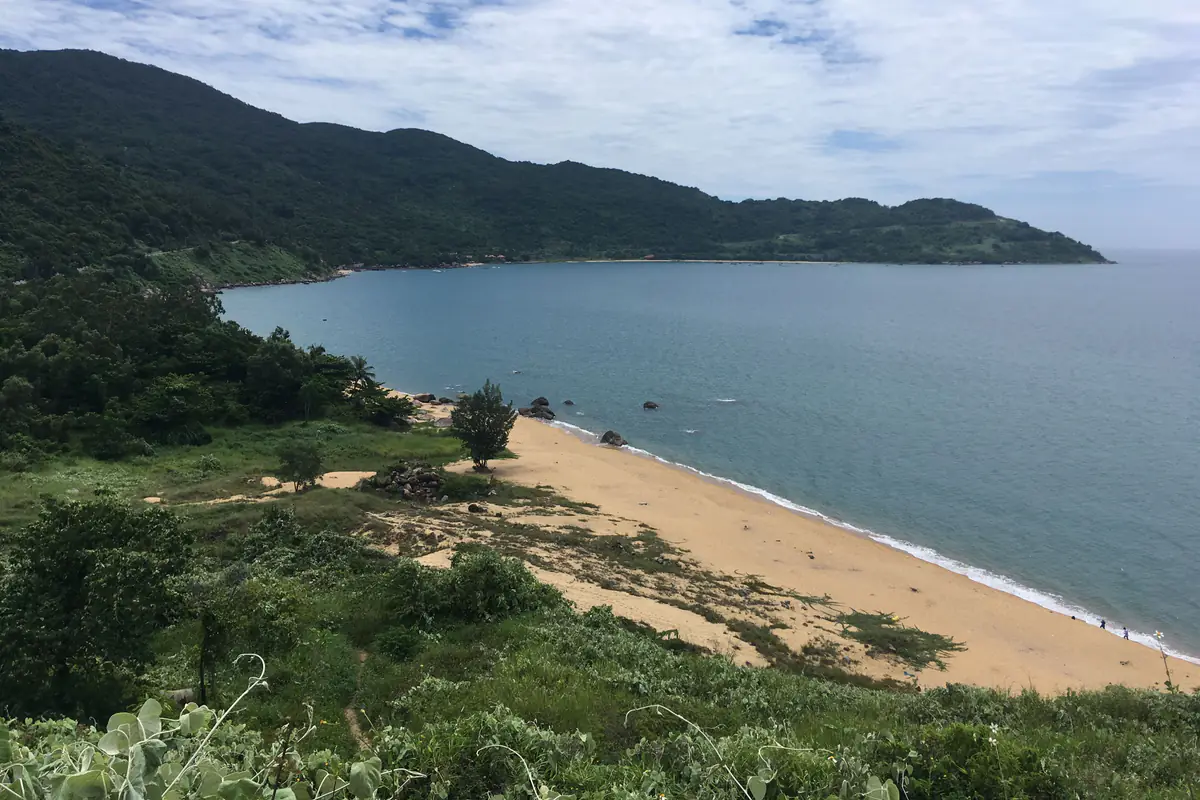
Photo: Christophe95
Getting up Son Tra
The roads around the peninsula are steep, with sharp bends, frequent fog and slippery surfaces in the rain. Only ride a motorbike here with a license valid in Vietnam and experience on mountain roads; automatic scooters are not allowed on the routes up to Ban Co (Bàn Cờ) Peak. The mountain routes are open 7:30am-5:30pm from October through February and 7:30am-6:30pm from March through September, and close as soon as there is a heavy rain or landslide warning, sometimes for the best part of a week in the wet season. In heavy rain or strong wind, save Son Tra for another day.
Nam O: fishing village and rock reef
At Nam O, basket boats are moored close to shore, a rock reef about 500 m long runs out into the sea, and the village is known for Nam O fish sauce, now listed as national intangible cultural heritage. From the first lunar month, green algae covers the rocks; it looks best at sunrise on a low tide.
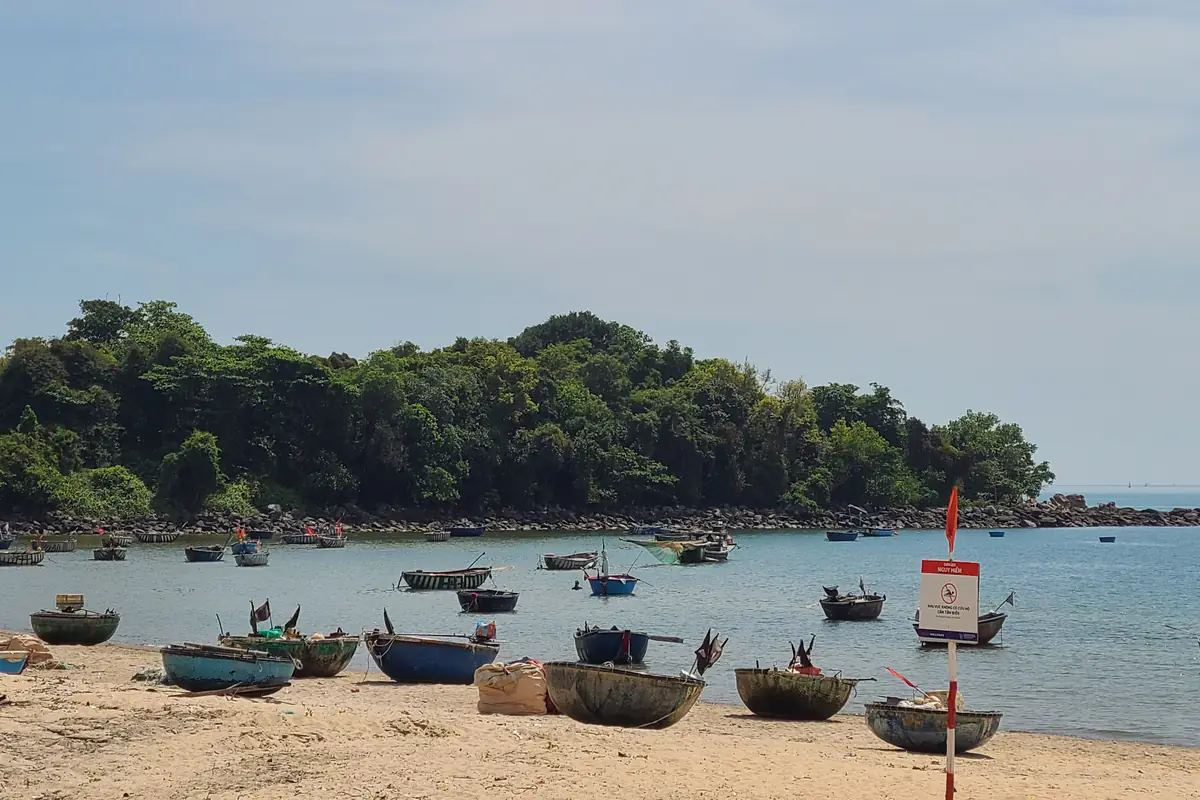
Photo: Bánhmỳchảo
Students have drowned off Nam O beach, and young children have been pulled out by waves after going in without an adult. Come here to walk and take photos from the sand, not to swim; the algae-covered rocks are very slippery, so keep off the edge of the reef when waves are breaking.
An Bang: already in Hoi An
An Bang (An Bàng) is about 25 km from the Dragon Bridge and makes more sense if you are staying in Hoi An (Hội An). After storm seasons that cut deep into the shore, Hoi An now has an emergency seawall of nearly 2 km along its coast. If you plan to stay by the sea at An Bang or Cua Dai (Cửa Đại), ask how much beach is left in front of the property and whether there is a buoyed zone with lifeguards.
When to swim #
Early morning belongs to the locals: the water is cool and the sand is not yet hot; if you arrive before the lifeguard shift starts, wait until the tower is staffed. Around midday the sun is fierce and UV bounces off water and sand, so you can burn even under an umbrella; we would rest, come back when the light slants and be out of the water before the shift ends. After dark, swim only at the two summer night-swimming areas, which have lights and lifeguards.
Which months the sea is calm #
| Month | Days with offshore waves under 1 m | Water temperature |
|---|---|---|
| January | About 1 day in 4 | 75°F (24°C) |
| February | About half | 75°F (24°C) |
| March | About 6 days in 10 | 76°F (25°C) |
| April-August | 9 days in 10 or more | 79-88°F (26-31°C) |
| September | Nearly 9 days in 10 | 88°F (31°C) |
| October | About 4 days in 10 | 85°F (29°C) |
| November | About 3 days in 10 | 81°F (27°C) |
| December | About 1 day in 10 | 77°F (25°C) |
These are marine model figures for recent years, using each day's peak modeled offshore wave height (1 m is about 3 ft), not measurements on the beach; water temperature is a monthly average. Whether you can swim on a given day is still up to the flags and the lifeguards.
April to August is the real swimming season. September is usually still calm but falls in typhoon season. From October the northeast wind arrives and waves build quickly; in December, the peak modeled offshore wave height reaches 1.5 m (5 ft) or more on over half of all days. If you visit then, treat a swim as a bonus and plan around the rain and floods.
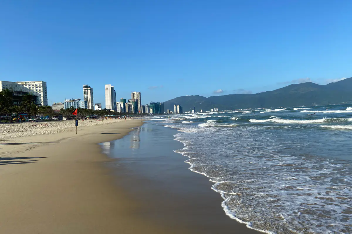
Photo: Kuroczynski
Buoys, flags, whistles and rip currents #
Lifeguards use flags to mark where you can swim and where it is dangerous, and give instructions by whistle and loudspeaker. A red flag, a no-swimming sign or a "rip current area" sign means stay on the sand, however flat the water looks. If you are not sure what a flag means that day, walk over and ask; with a large group, tell the lifeguard before everyone goes in.
A rip current is a narrow channel of water running fast from the shore out to sea. The sign to remember: a calm-looking gap with no breaking waves between two stretches of surf is often a rip, exactly the spot that looks easiest to swim in.
Do not swim after drinking or when you are exhausted. If you have a heart condition or high blood pressure, ask your doctor whether sea swimming is suitable for you. With small children, an adult stays within arm's reach and watches them the whole time; a life jacket helps a child float but does not replace supervision.
Jellyfish: look before you go in #
Stinging jellyfish (sứa lửa) usually turn up off Da Nang between roughly March and August, especially on hot days; some years a large jellyfish has drifted into the swimming area in front of Bien Dong Park as early as April. Scan the water before you go in and listen to the lifeguard announcements; wear water shoes if you walk along a rocky waterline.
FAQ: swimming in Da Nang #
Can I rent a jet ski or go snorkeling on Son Tra?
The jet skis, banana boats and coral snorkeling trips offered at Bai Ran (Bãi Rạn) and Bai Da (Bãi Đá) on Son Tra are not licensed and do not meet rescue requirements. If you want a water activity, pick an operator that can show its license and permitted area, provides a life jacket for each person, and answers your questions before you pay.
Which beach is best with small children?
The beach in front of Bien Dong Park, between April and August, early or late in the day; let children in only inside the buoys while lifeguards are on duty, keep an adult within arm's reach the whole time they are in the water, and rinse off at the showers nearby.
Related posts
Islands & beaches
Nha Trang Beaches: Where and When to Swim, and What to Know First
Pick a stretch of beach for what you want, swim at the right time, read the buoys and flags, keep your things safe and know what to do about sea urchins and jellyfish.
Guides
Where to Stay in Hoi An (Hội An): Old Town, Villages or Beach
The best area to stay in Hoi An depends on your evenings: the old town, the villages, the beach or a day trip from Da Nang. Plus car-free hours, beach erosion and flood season.
Food
Nha Trang Cafes: Sea Views, Rooftops, Retro Rooms and Capybaras
Beachfront cafes for the morning, rooftops for sunset, retro rooms in the old streets and two capybara cafes, plus how to order Vietnamese coffee.